いくら情報操作しようとしても、結局無駄です。ははは。Power to People.
ゼロヘッジ(3月25日)掲載記事:
瞬間的なクラウド・ソースの情報伝達、分析の時代に、情報を抑制しようと政府がどんなに努力しても結局は失敗する。そのいい証拠が、日本の”Pachube"が製作したグーグル・アースをベースにした3Dのガイガーカウンター値のInteractive地図。Pachubeコミュニティはこのほかにもクラウド・ソースのリアルタイムの放射線監視ツールやウィジェットを提供している。そのうちに、日本の放射線の影響を受けている地域の隅から隅までカバーするだろう。政府が「現在測定中」と言って情報を抑えようとしても、クラウド・ソースには勝てない。
Confirming that in a time of instantaneous crowdsourced information distribution and analysis, any attempt by a government to institute an information blackout of any nature is doomed to failure, is the following amazing Google Earth-based 3D interactive map of Geiger readings from Japan. And if that is not enough, the Pachube community has released an extensive selection of crowd-sourced realtime radiation monitoring tools and widgets, focusing on as many Japanese territories as possible. Shortly we are confident all geographical holes will be filled, and every square mile of the affected territories will be mapped out surpassed the government's "Under Survey" blackout attempts.
Make sure to have the GoogleEarth API set up in advance of checking out the plugin.
プラグインを試す前に、グーグル・アースのAPIがセットアップしてあることを確認しよう。

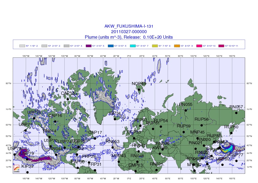
Additionally, here is the most recent updated global radioactive fallout per ZAMG.
オーストリアの気象サービス会社が出している、放射性物質降下の状況図。
And a complete list of all the available crowdsourced radiation maps, applications and tutorials
- #geigermaps by @haiyan (ガイガーマップ)

- javascript map by @motoishmz

- Instructions for connecting up a geiger counter to Pachube (in Japanese) by @kotobuki
ガイガーカウンターをPachubeに接続する方法の解説(日本語)
- RDTN by @rdtnorg

- All feeds on Pachube, mapped by search 'radiation' by Pachube

- Hacking a Geiger Counter in Nuclear Tokyo by akiba

- 3D realtime radiation in Japan (below) by uh
3Dリアルタイム放射能
h/t Themos Mitsos

No comments:
Post a Comment